
On 28 September, the world observes the International Day for Universal Access to Information with the theme “Ensuring Access to Environmental Information in the Digital Age.” We asked Dr. Ricardo Bagarinao, Professor and Chair of the Doctor of Sustainability program, to share his insights on how accessible environmental information can help tackle today’s major natural and human-made challenges.
In the middle of December of 2011, Typhoon Sendong traversed the Northern Mindanao region and eventually struck Cagayan de Oro. It was considered a mild tropical cyclone with sustained winds of 100 km/hour. What made it devastating, though, was the volume of rain it brought, comparable to the rainfall caused by Typhoon Ondoy in 2009. By the time the storm ended, it left 1,292 dead, 1,049 missing, 2,002 injured, and 10,806 families affected. The economic losses were estimated at P2B.
In response to this typhoon, the Philippine government launched Project NOAH (Nationwide Operational Assessment of Hazard) in 2012 to support the country’s disaster risk reduction, climate change adaptation, and mitigation using disaster monitoring and early warning technologies. The project has also converted hazard maps into local risk assessments showing the vulnerability of each community to disasters. Initially run by the Department of Science and Technology, it is now supported by the University of the Philippines through the UP Resilience Institute.
The scenario-based data on Project NOAH’s portal is an example of science-based information that empowers local government units and the general public to plan for disaster risk reduction initiatives. The accessibility of such information can spell a difference in saving lives and protecting properties during disasters.
Dr. Ricardo Bagarinao, Professor and Program Chair of the Doctor of Sustainability program at the UP Open University, highlighted the huge importance of accessible and reliable environmental data in enabling the public to make well-informed decisions on risks associated with climate change, including natural hazards and biodiversity threats.

Dr. Bagarinao’s research focuses on landscape ecology, land use changes, environmental management, disaster preparedness and risk reduction, and GIS-based spatial analysis.
“When we speak of greater accessibility of data, we mean that such data can be retrieved at any time and from any location. Any decision-maker, whether individuals, households, local government units, or business owners, should be able to access this data to be able to respond appropriately whenever an environmental challenge takes place,” he explained.
Dr. Bagarinao cited the important role that accessible environmental data plays in his academic work, particularly in research. In his study on the vulnerability of UPOU’s students to certain hazards, he used a national vulnerability map for each hazard and overlaid it with student distribution maps. This overlay helped identify which students are vulnerable to specific hazards.
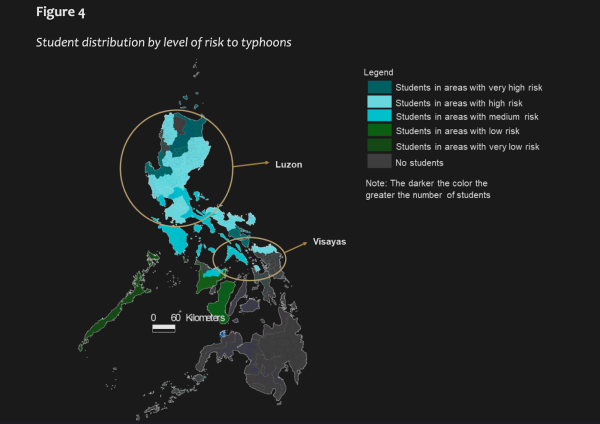
Bagarinao’s study indicated that most learners are in regions with high to very high risks to climate-related hazards. (Source)
“Fortunately, the Manila Observatory has made these maps accessible at that time. Those maps have helped me analyze and identify students who are highly, moderately, and less vulnerable to floods, earthquakes, and typhoons,” he said. He added that the study’s findings can help address the support needs of students affected by typhoons and floods.
Environmental information is not only critical in disaster preparedness but also for guiding community development plans. For example, Dr. Bagarinao emphasized that information on endemic or endangered species assists decision-makers in determining whether a development should proceed and helps institutions negotiate with the government restrictions for biodiversity conservation.
Dr. Bagaranao also explained how geo-hazard maps can guide real estate buyers in the purchase of suitable properties, help developers and local government units to design and implement measures to mitigate these potential hazards.
In agriculture, clear data on extreme weather cycles can help farmers plan and choose agricultural practices that are more resilient to these weather conditions. Fishing communities may also need reproductive cycle data to time their fishing activities for greater sustainability.
The way the data is presented and distributed also matters. Dr. Bagarinao said, “The data should be understandable by these users, meaning, they are presented in a clear, simple, and meaningful manner, using plain language or visuals, so that non-experts can readily interpret and appropriately use it.”
Written by Dr. Primo Garcia